
Clear Water Bay Orienteering Course
Maps
(Printing on A4 size paper is recommended for accurate scaling.)
Cross Country Courses
| Detail | Level | ||
|---|---|---|---|
| Beginner | Intermediate | Advanced | |
|
Length* (km) |
0.7 |
0.9 |
1.1 |
|
Climb (m) |
30 |
40 |
50 |
|
No. of Controls |
10 |
12 |
15 |
|
Map (click to download) |
|
|
|
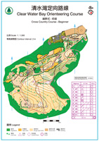

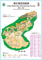
* Measured as straight line distance between controls.
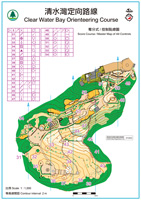
Score Course / Master Map
Total no. of controls: 24
Start and Finish Location
Entrance to Tai Hang Tun in Clear Water Bay Country Park
How to get there:
Take public transport to "Tai Au Mun" bus stop. Walk along the Clear Water Bay Road about 1 km (around 30 minutes) to the car park at its end. The start & finish location can be reached through a paved footpath.
For more information on orienteering, click here.